


STAGE
STAGE 2 OITA-KUMAMOTO
LOCATION
FINISH: Minamiaso (Minamiaso Village Office)
A line race starting in front of Bungo-Ono City Hall, passing scenic attractions such as Harajiri Falls and the Kuju Highlands.
Riders then head south along the Yamanami Highway, racing through the magnificent scenery created by the ridgelines and grasslands of the outer rim of Mt. Aso, before finishing at Minamiaso Village Hall.
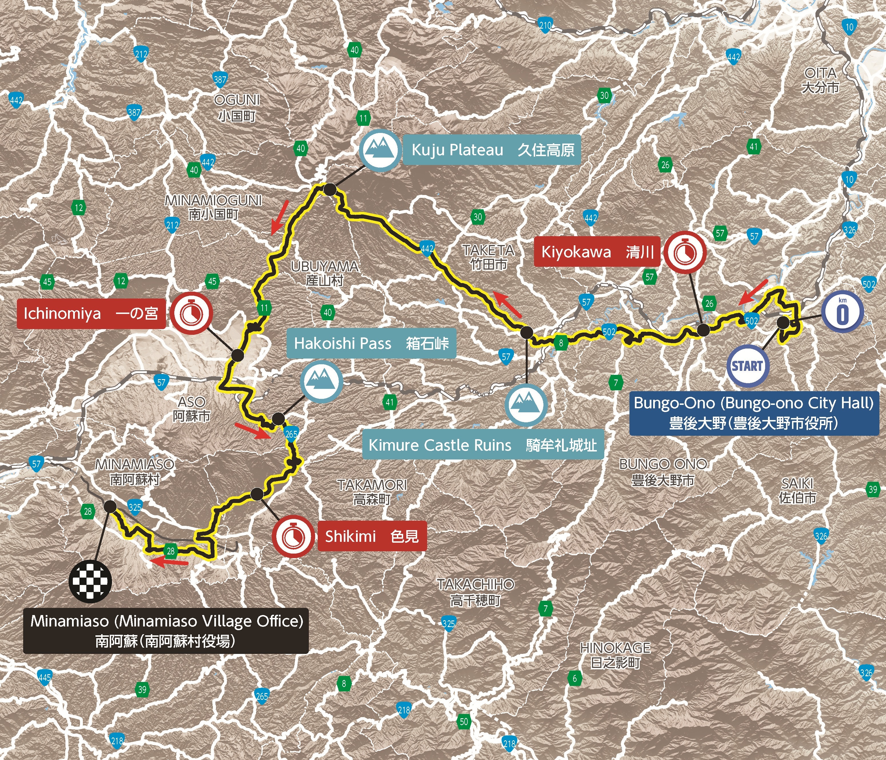
©2026 ZENRIN CO., LTD.
Note: The official course profile (distance, elevation, etc.) announced by the Tour de Kyushu 2026 Executive Committee is based on data from VeloViewer—the tool recommended for international road races—rather than Ride with GPS. Please be aware that discrepancies in distance and elevation figures between VeloViewer and Ride with GPS arise from differences in the measurement methods used by each application.
| CaravanEst. Arrival | RidersEst. Arrival | |
|---|---|---|
|
START
Bungo-Ono City Hall
|
9:20 | 10:00 |
|
SPRINT POINT
Kiyokawa
|
10:10 | 10:40 |
|
VIEWING POINT
Taketa Castle Town
|
10:30 | 11:00 |
|
KOM POINT
Kimure Castle Ruins
|
10:40 | 11:10 |
|
VIEWING POINT
Kuju Flower Park
|
11:00 | 11:30 |
|
KOM POINT
Kuju Highlands
|
11:10 | 11:40 |
|
SPRINT POINT
Ichinomiya
|
11:40 | 12:10 |
|
KOM POINT
Hakoishi Pass
|
12:00 | 12:30 |
|
SPRINT POINT
Shikimi
|
12:10 | 12:40 |
|
FINISH
Minamiaso Village Office
|
12:40 | 13:10 |
*The times shown for “Caravan Est. Arrival” and “Riders Est. Arrival” are estimates based on the race progressing at the “expected maximum speed” set for each stage (in 10-minute increments; 48km/h for the Saga-Fukuoka stage and 44km/h for the other stages). Actual arrival times may differ from the times above depending on how the race unfolds.
*Please also note that part of the caravan operation within the circuit course may be changed based on decisions made on the day (for example, reducing two laps to one).